Introduction
This virtual tour
will let you navigate the Tejon Ranch and see for yourself why this magnificent
landscape
has
served
as
a natural
laboratory
for scientists
studying natural history, biogeography, and the processes of evolution.
Because of the Ranch's unique location, historic field studies here in
the late 1850's significantly advanced scientific knowledge about the
plants and animals of the West, and ongoing research in this region continues
to further our knowledge of how species and habitats evolve, function
and
interact.
The Tejon Ranch lies at the boigeographic crossroads of five geomorphic
provinces and four floristic regions, all within the global hotspot recognized
by scientists as the California Floristic Province. Within this hotspot,
the 270,000-acre Tejon Ranch supports 23 different vegetation communities
(60% of the communities in the region), Critical Habitat for the endangered
California condor, and potential habitat for 20 state and federally listed
species and 61 other rare and endemic species, all within about 40 miles
of the largest population center of California. Tejon Ranch provides
a unique opportunity to conserve low-elevation grasslands and oak woodlands
that are under-protected in the region. Significant conservation on the
Ranch is also crucial to ensuring that existing conservation investments
remain intact and to linking the Sequoia National Forest with the Los
Padres
National Forest.
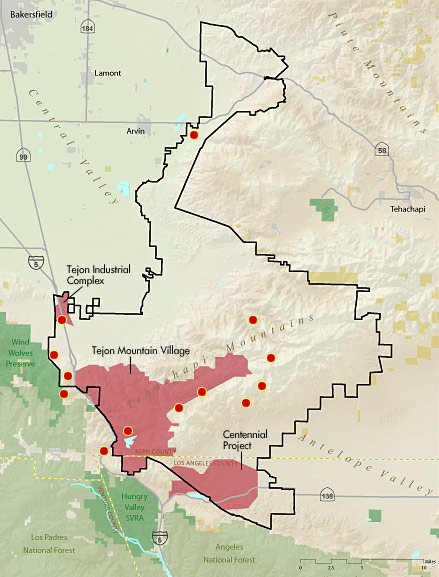
Threats to this important landscape are enormous. Three major development
projects are partially completed or planned for the Ranch in the near
future:
- The
approved Tejon Industrial complex will destroy 1,100 acres of farmland
and grasslands and lies within a potentially crucial wildlife linkage
along the Kern County Valley floor.
- The proposed Centennial project along
Highway 138 in North Los Angeles County will replace over 12,000
acres of grasslands, juniper woodlands,
oak woodlands, chaparral and scrublands with approximately 25,000
homes and associated retail and commercial uses.
- The proposed Tejon Mountain
Village, located in the secluded hills and canyons area surrounding
Tejon Lake, will impact approximately
37,000 acres
of oak woodlands, grasslands, chaparral and scrublands, montane
hardwoods and conifers, pinyon-juniper woodlands, wet meadows and riparian
woodlands.
Start the Virtual Tour
|